




- Calibsun | Expertise
Irradiance Spatialisation for Large-Scale PV Plant
One point GHI data is not enough for PV plants above 50MWp
On utility-scale photovoltaic plants above 50 MWp, a single pyranometer cannot represent the solar radiation reaching the modules. As footprints scale from hundreds of megawatts to several gigawatts, irradiance becomes spatially heterogeneous across the land surface.

A passing cloud rarely shades the full site at once
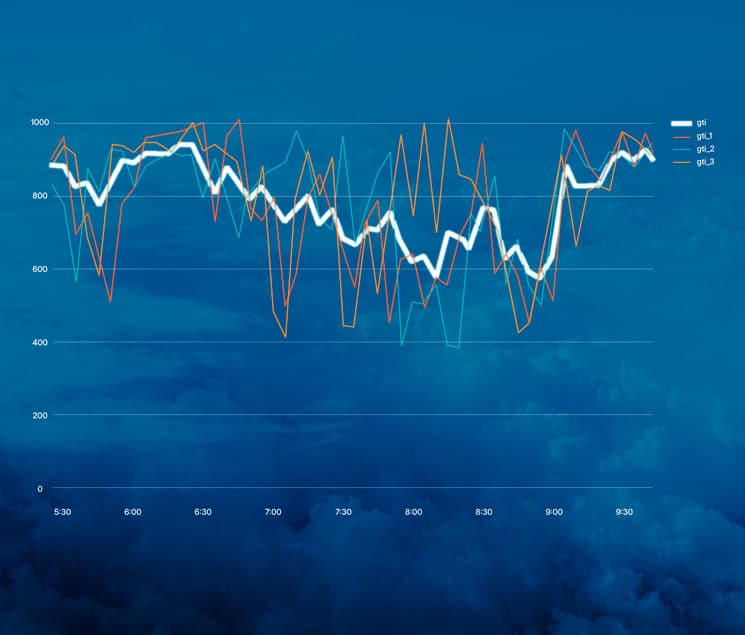
Production drops occur locally while other sections remain under clear sky. A pyranometer captures one location only. It misses these complex spatial patterns and weakens the correlation between measured GHI (Global Horizontal Irradiance) and actual energy output.
This limitation is now recognized by the IEA PVPS Task 16 guidelines, which recommend approximately one GHI measurement per 10 MWp to characterize the irradiance field across large installations. In practice, most forecasting providers rely solely on satellite resources and ignore this density of ground data. None exploit it through a rigorous spatial analysis.
CalibSun is the only provider that natively integrates on-site data and performs true GHI spatialization. The method is based on internal scientific research, validated through exchanges with a main contributor to IEA Task 16, and applied operationally on large-scale plants.
CalibSun's geospatial approach to irradiance spatialisation
CalibSun has designed a GHI spatialization methodology to close this gap. The process does not require a fixed number of pyranometers. It requires the precise location of each sensor across the plant as its primary input.
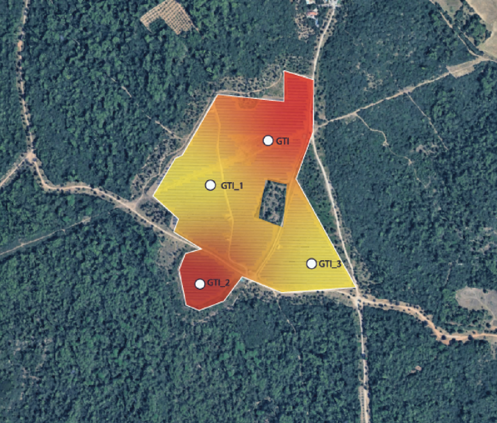
Once sensor positions are known, CalibSun applies geospatial and geostatistical methods to model the covariance (the spatial variability) between each pair of sensors. This step quantifies how irradiance at one point relates to conditions elsewhere on the site surface.
CalibSun then applies kriging, a geostatistical interpolation method, to estimate local irradiance across the full plant footprint. The configuration of the sensor network defines the accuracy of this estimate. The result is a continuous spatial representation of the irradiance field. From this surface model, computed grid square by grid square, a spatially averaged GHI is derived.
This value reflects the true GHI of the plant far more accurately than any independent sensor. It produces a significantly stronger correlation with measured power production.
A decisive gain for very large plants
The larger the plant, the more critical spatialization becomes. CalibSun considers the approach recommended from 50 MWp and mandatory above 100 MWp. At this scale, it marks a turning point in forecast quality.
Only a spatialized irradiance field can capture the localized production drops caused by non-uniform cloud cover across spatial fields. Point GHI data systematically misrepresents these drops.
By resolving spatial patterns and short-term variability, GHI or GTI spatialization improves both short-term forecasting and day-ahead forecasting. The impact is direct: more accurate scheduling, sharper trading positions, and better-informed grid-balancing decisions.
Innovative internal research
applied in the field on+1.4GWp solar plant

A CalibSun exclusive
CalibSun is the only forecasting provider applying true GHI spatialization at this scale. The principle aligns with IEA PVPS Task 16, yet its operational implementation remains rare across the industry.
The technology stems from CalibSun’s internal research and was presented at ICEM 2025 (International Conference on Energy & Meteorology), confirming its scientific maturity. It is deployed on some of the most demanding sites worldwide, including a +1.4 GW solar plant in India where monsoon-driven cloud variability makes irradiance modeling exceptionally difficult.

- Questions
Frequently Asked Questions about Spacialized GHI & GTI
What is GHI spatialisation?
GHI spatialization reconstructs the Global Horizontal Irradiance field across an entire solar plant rather than relying on point GHI data. Based on sensor location and geostatistical interpolation (kriging), it produces a continuous spatial representation of solar radiation and a spatially averaged GHI that correlates closely with real production.
Why is a single pyranometer not enough?
On large plants, cloud cover is rarely uniform. One pyranometer measures irradiance at a single location and misses localized production drops elsewhere. This weakens the link between measured GHI and actual output.
From what plant size does spatialization become necessary?
CalibSun recommends it from 50 MWp and considers it mandatory above 100 MWp, where spatial variability strongly affects production.
What is kriging and why is it used?
Kriging is a geostatistical interpolation method that estimates values across a continuous surface from the covariance between known points. CalibSun uses it to produce an optimal, spatially averaged GHI across the plant.